Sunday, 26 August 2012

EXMOUTH AND CAPE RANGE NATIONAL PARK

Leaving Tom Price, we headed west towards the coast and pulled in at Nanutarra Roadhouse to get the air conditioning going to cool down the van.   After a hot, windy night, the hottest night we've experienced since leaving Melbourne, we continued west, then turned north-west towards Exmouth and North West Cape.  North West Cape is a fairly narrow peninsula with sea on both sides, so it was a great relief to feel that sea breeze.  Ningaloo Reef runs along the western side of the peninsula while Cape Range runs down the middle.  Still, it is an arid peninsula covered in low coastal grasses and shrubs, with very few trees. Near the cape, tall masts rise into the air, part of the US naval communications system.  Evidently, Exmouth was established in the 1960s to support the military bases.  There is an Airforce base south of Exmouth at Learmonth, then a little further south a US solar observatory.

Since Ningaloo Reef is so close to shore, we decided to invest in some snorkelling equipment.  Having got organised for an all day expedition to Cape Range National Park and the reef, we awoke that morning to find a thick fog rolling in from the sea.  Deciding to skip snorkelling that day, instead we embarked on a reconnaissance mission to explore the length of the National Park.

Fog at base of some masts

Ningaloo Lighthouse


View from the lighthouse.  Whales could be seen offshore.
The reef seen close to the shore

The Range that bisects the park


Sea Eagle's (Osprey) nest on tower at Visitor Centre

Daisies in the dunes

CHARLES KNIFE GORGE

The blustery, cool southerly blew for the third day in a row, so we headed down the east side then turned inland to the range.  The road followed a ridge and, lo and behold, there were spectacular gorges and chasms either side of the road.


Learmonth airport and airforce base in distance
Finally the wind dropped to a reasonable breeze, so we headed to Yardie Creek at the end of Cape Range National Park and boarded a Department of Conservation boat for a trip up the gorge.  The fairly rare black-footed rock wallabies inhabit the gorge as well as numerous species of birds.

Mouth of Yardie Creek


Yardie Creek Gorge

Black-footed rock wallaby


The snorkelling went less well.  At full tide there was a strong current, too strong for me to get out to the reef, though Eric managed to see some coral and fish.

Wednesday, 22 August 2012

TOM PRICE

Tom Price is something of an oasis, though basically just a mining town.  We drove up a steep, very rough, rocky track to the top of Mount Nameless, which gives 360 degree views over the town, the mines and the countryside.


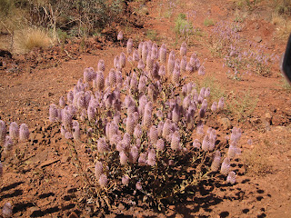
Mulla mulla in bloom
Mount Nameless
Eric did a tour of  'the mine' and came back full of facts and figures.  He was surprised that I refused to go.  I was surprised that he didn't realise that I hate what they're doing to the land.  The sight of the great rents and gouges in this ancient, fragile land fills me with horror.  As for the miners, I heard an estimate on RN that their campaign against the Resources Rent Tax had cost Australians 100 billion dollars in lost revenue.  As for paying them any more to view their destruction up close, harrumph! I say.

Eric can tell you about Rio Tinto's activities in this spot:

The Tom Price mine is a 8km x 15km site on land which was 'inherited' by Lang Hancock from his father who was one of the early explorers in the area. The ore body was identified by Lang (who also found the asbestos deposit at Wittenoon) and the quality was confimed by Tom Price (a geologist with Kaiser Steel US) who had the contacts to enable development. Originally Hammersly Steel established a company mining town (a drinking town with a mining problem). The town was sold to the local shire for $1 and has been subsequently developed into a town of several thousand with 2 primary schools and 1 secondary school. Rio Tinto now own the mine, and a number of others in the area and the railway line to Karatha.
The mine tour was a confrontation with huge Tonka trucks, ore crushers, piles of ore etc and massive numbers of the extent of the ore body, tonnage extracted daily and transported by the 134 trucks per train load ($3,500,00 per train), accommodation for 800 fly in/ fly out workers and the size of pay packets. Women comprise 40%  the workforce with a large number driving the huge trucks. The trucks have massive 16 litre diesel engines which power a generator as the operation of the truck is all electric.All instructions to the plant operators, truck drivers etc including the bus driver for the tour come by radio from Perth in real time. Rio is predicting a further 50 years extraction for the mine.


Crushing plant


Saturday, 18 August 2012

THE PILBARA

After leaving Port Hedland, we headed inland for about 60 kms south to Indee Station and camped there for a couple of nights.  This part of the Pilbara is pretty flat and open.  The station had mustered cattle the day before we arrived and had them penned in the home yards.  Next morning the animals were loaded onto trucks and shipped out.

The owners of the station (though I think most cattle runs in WA are leasehold), Colin and Betty, put on happy hour daily for staff and travellers - free nibbles provided, bring your own drinks - which is a good opportunity to chat with other campers.  Few of the station staff were able to join us at that time as most were recovering from a severe viral illness, or otherwise occupied with cattle.  Colin has had the station for 50 years and, at 74, also works two days a week in the mine.  Camping facilities were basic, but adequate.

The main attraction at Indee Station is Red Rock where many ancient aboriginal petroglyphs can be seen.  We found them difficult to locate, but after some time scrambling over the hot rock, we were eventually successful.

Red Rock


View over Indee Station from Red Rock

View of campground from nearby hill
Indee Station was also the site of a 1968 aeroplane crash in which 28 people died.  A wing of the plane sheared off and crashed into the fuselage, evidently due to some creative but faulty aircraft maintenance in Perth. (http://en.wikipedia.org/wiki/MacRobertson_Miller_Airlines_Flight_1750) There is a memorial to the crash victims near Red Rock together with bits and pieces of the wreckage.

Travelling inland further south along the Great Northern Highway, the flat terrain is increasingly dotted with low hills.  There seems to be a mine located everywhere there is a low red hill or two.  Road trains ply the road and a railway line runs mostly parallel to the road where trains of enormous length ferry their cargo of Pilbara rock to port.  Dig it up and ship it out!

From the road we could see a few camps for miners - rows of dongas plonked down on the dirt under the blazing sun, and it's still winter here.  I'm told they work 12 hour shifts with maybe one day off each month.  Their accommnodation may be a room little larger than a walk in wardrobe with room for a bed, a small fridge and not much else.  What a life!


KARAJINI NATIONAL PARK

We'd heard a lot about how fabulous Karajini was - best National Park in WA according to many - but driving in to the fairly flat, spinifex covered campground made me wonder what the fuss was about.  Allocated a site on crushed red rock without any shade was not very encouraging either.  However, it seems that Karajini is all about the gorges.  Near Dales campground is Dales Gorge.  A steep climb down (of course, it's a gorge) leads to Circular Pool, then further on, the pretty Fern Pool where maidenhair ferns grow wild.  At the other end of this gorge is Fortescue Falls.

Fern Pool

The eponymous vegetation


Fortescue Falls


Circular Pool
There are no fossils in these rocks as they were formed from lava about 3.5 million years ago before there was life on earth.  You just have to look at these rocks and you can pretty much see that they're full of iron.  Try picking up even a small one and it's extremely heavy.  There is also supposed to be asbestos in this gorge.


Forty-two kilometres along a teeth-chatteringly corrugated dirt road was the most spectacular gorge, series of gorges really, that we have ever seen.  It made us wonder how breathtaking it must be to see the Grand Canyon.


The wildflowers were out, but those lining the road were covered in red dust and struggling to survive.  I thought that by now I was an old hand when it came to dealing with red dust. Generally it just brushes off, but the red dust at Karijini was different, not the sort you could brush off, but the sort that stuck.  We were all walking around with our clothes smeared with red dirt.


Driving west from Karijini, we crossed the Hammersley Range to Tom Price.  The range is mostly made up of hills  rounded by erosion, not as spectacular as the Kimberley perhaps, but interesting none the less.


Sunday, 12 August 2012

PORT HEDLAND

A mining town - actually two towns - with South Hedland about 18 kms away.  Port Hedland is the deep water port for shipping out mine products extracted by BHP, Rio Tinto and Fortescue Metals.  This morning I counted 13 large cargo ships standing off shore, presumably waiting to receive their cargo.


Rio Tinto has a large salt producing works here:


While people working in the mining industry make good money, they seem to work very long hours and accommodation is difficult to get and very expensive.  The asking price for ordinary looking houses is in excess of $1.5 million.  The young woman who cut my hair in South Hedland was renting a small unit for $900 per week and she and her partner had to share this unit with another couple!  The old Detention Centre is currently being used to house workers.


View from behind our van, looking towards South Hedland
There's not much to spend money on in this town.  Neither Port nor South Hedland boasts a book shop.  At least Broome had two good book shops.


Old quarters for medical staff
 Tomorrow we're heading south to Indee Station, then on to Karijini National Park.