Saturday, 11 August 2012

DERBY TO EIGHTY MILE BEACH via BROOME

DERBY (CONT'D)
Before leavng Derby we visited the old boab prison tree which had been used as a temporary lock up.  Aboriginal people from west Kimberley were kidnapped by blackbirders, or evicted from stations, chained together and marched to the coast where some were used as divers for the pearling industry.

Located about 35 kms south of Derby, in the middle of nowhere, is the Curtin Detention Centre at the site of the disused Curtin Airforce Base which reputedly has the biggest and thickest runway in the southern hemisphere.  The idea was that this runway could serve as an alternative landing site for America’s space shuttle.  There is talk that the Americans may use this base to land the heavy equipment for their proposed Darwin base and then truck the equipment overland, seemingly a logistical piece of cake for the Yanks.
We were told that Curtin Detention Centre currently houses about 800 males – Afghans, Iraqis, Iranians and heaven knows who else.   Yesterday the temperature at Curtin was 34 degrees and from now on it will only be getting hotter.  Little wonder that such a place produces so much mental illness.

BROOME
The town of Broome didn't hold a lot of attraction for us.  It's a very touristy place with old and new corrugated iron sheds and shops, with many shops in the business of flogging pearls.

Broome claims to have on display the "World's largest fine quality round pearl":


There is the old outdoor picture theatre

and, of course, famous Cable Beach


with its camel rides


and spectacular sunsets:


We were lucky that on our second morning, there happened to be a very low tide so the dinosaur footprints at Gantheume Point were visible.  Along with a couple of dozen other early risers, we managed a 7 am scramble over rocks down the cliff to view and photograph these prints - yep, more dinosaur relics.


A highlight of our time in Broome was a visit by my friend, Mary.  It was good to see someone from home and catch up on the news.

We all enjoyed a trip to Roebuck Bay Bird Observatory, east of Broome.  Thousands of migratory shore birds visit Roebuck Bay annually, many of them from as far away as Siberia.  This is supposed to be the most significant site in Australia for shore birds.  Unfortunately, we visited at low tide when there were few shore birds to be seen on the water, but there were plenty of bush birds around, as well as some native wildlife.


Our last night in Broome coincided with the 'Staircase to the Moon' phenomenon where the reflection of the full moon rising over the mud flats of Roebuck Bay gives the illusion of a staircase up to the moon, but our camera was not good enough to capture the full effect.

CAPE LEVEQUE
We had been thinking about taking the tent and camping on the Dampier Peninsula for a few days.  In the end we opted for a (very) full day tour - picked up at 7 am and returned at 9.30 pm.  This turned out to be a good decision as the first half of the drive (about two hours) is on a badly corrugated road.  As well, the whole road to Cape Leveque is away from the coast and straight through the middle of the peninsula's bushland, so there's not a lot to see until you get to the top, unless you turn off on one of the side roads to the coast.
Altar decorated with mother of pearl at Beagle Bay Church

Inevitably on a tour, you're taken to a place that wants to sell something.  In this case it was Cygnet Bay Pearl Farm, though I must admit that the descriptions of pearl seeding, growing and harvesting were interesting.
Cygnet Bay
At One Arm Point we visited Ardiyooloon Hatchery:


Then, late in the afternoon, arrived at the indigenous owned and operated Kooljaman Resort.
From Kooljaman Resort at Cape Leveque

Sun setting over cliffs at western beach, Cape Leveque

PORT SMITH

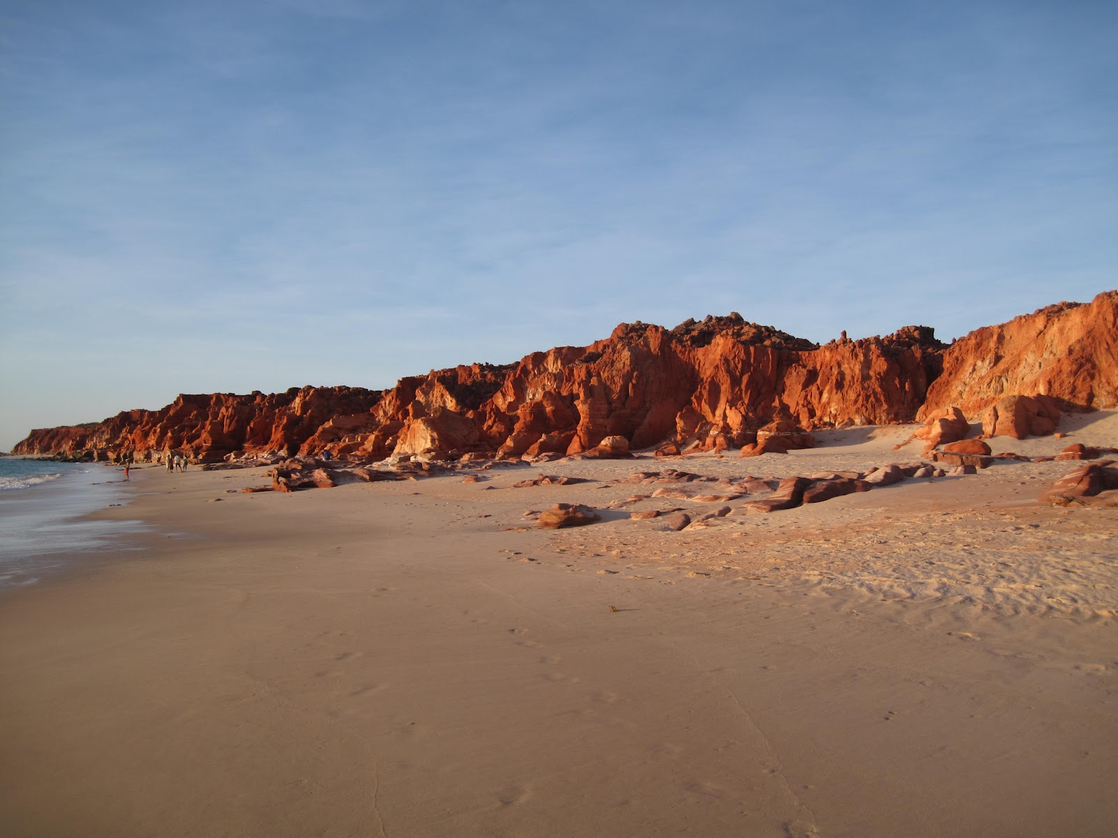
About 140 kilometres south of Broome and 23 kms off the highway along a good dirt road is Port Smith.  The camp ground is situated near a mangrove lined lagoon where the swimming is good at high tide.  At low tide there is a long walk out over mud flats to reach the water.  The sand flies feasted on me and I'm still scratching.


Driving around the coast revealed some spectacular coastal scenery


and strange birds


EIGHTY MILE BEACH

Further south down the highway is the turnoff to Eighty Mile Beach located on a cattle station about 10 kms in along a somewhat corrugated dirt road.  White sand and shells, torquoise water and a temperature of 32 degrees, but you can't swim!!!  So what do you think people do?


Some people did venture into the water but, as they were catching sharks off the beach, we contented ourselves with paddling.

Friday, 20 July 2012

HORIZONTAL FALLS

We had the best day yesterday with our trip to the Horizontal Falls.  I was afraid it was just going to be one of those things hyped up for tourists but the scenery really was spectacular.  The falls themselves are nothing much - just where the sea is forced between narrow gaps on the incoming tides, but the tour operator made it a lot of fun by tearing through the narrows and swerving the boats about.


One section of the horizontal falls
After a thirty-five minute flight in a seaplane over the Derby mud flats and the beautiful Kimberley country, we landed in gorgeous Talbot Bay and taxied to pontoons moored there by the tour company.


Mud flats


Pontoons in Talbot Bay


Aerial view of both falls

The sea was turquoise coloured, the temperature was about 30 with a light breeze and the scenery was spectacular.  The view from the top deck of the pontoon reminded me of the Greek islands.  Lovely.


View from the pontoon


After a session feeding the sharks:


we cruised through Cyclone Bay and Cyclone Creek - an area where boats and cruise ships take shelter when rough weather is forecast -


before tackling the wider of the two horizontal falls:


When the skipper checked out the narrower gap, it was obvious that there was a significant difference between the water levels each side of the gap and he deemed it too dangerous to attempt a crossing at that time.  So back to the pontoons we went for our lunch of barramundi and salad.


After lunch we returned to the second "fall".  By this time the water levels had evened out to the point where we could get through.  (These falls are totally dependent upon the tides and we had ascertained that Thursday was the best day this week.)


Once through the gap, we cruised about the "Inland Sea" for a while so that, by the time we were ready to return, the sea levels either side of the gap were about equal.


Back in the air, the return flight followed the coast to Derby


but we ran out of camera battery before we got back.

A fabulous day in the beautiful, beautiful Kimberley.


Wednesday, 18 July 2012

DERBY AND WINDJANA GORGE

Driving into Derby, from either the Victoria Highway or the Gibb River Road, is like driving through an avenue lined with gold.  Especially in the early morning light, the acacias are a glorious sight, the gold of wattles contrasting nicely with the red dirt.


Derby is a town of about 5,000 people so most services are available here.  Its main function is to serve as a port for the export of live cattle and minerals.  As it's school holidays in WA, there are lots of kids around the streets.  A favourite pastime in Derby is to watch the sunset from the jetty.  There's a restaurant strategically placed at the end of the jetty so we took the opportunity to watch the sun go down from there.


Derby tides are 5th highest in the world - up to 11 metres.


Derby mud flats

WINDJANA GORGE

The best gorge we've seen so far, ie the prettiest, perhaps because the walls and water are closer.


Freshwater crocs inhabit the gorge


We walked the length of the gorge (well, the part that was open) in the middle of the day and it was very hot - 33 in Derby.  Some of it was quite hard walking as it involved trudging through thick, coarse river sand, out in the open.


About two and a half hours later, we returned and were pretty exhausted, as much from the heat as anything else.


Are you tired of photos of rock yet?  I know it all looks pretty much the same in the photos, but it really is quite awe inspiring to actually see these sections of the fossilized reef.  Our photos don't really do it justice.  It's hard, no - impossible, to capture a sense of the sheer scale of the thing which extends over a vast distance, let alone the variations in colour and texture.

Tomorrow we're doing a flight over the so-called Horizontal Falls as well as "an exhilarating thrill ride" through the falls.  I think I'll give the swim in the shark cage a miss.  I hope they mean shark free cage