Wednesday, 13 June 2012

RICHMOND - MOUNT ISA

As we neared Cloncurry, the grass plains gave way to open woodland then the rugged Selwyn mountain range.  Again, the bush was in bloom with mainly wattles and white flowered eucalypts in flower.


On the way through Cloncurry we passed the caravan park we'd stayed at previously and were startled to see the ground carpeted with green grass!  When we were last there, it was red dirt with nary a blade of grass to be seen.  That reminds me that the tour guide / cockie back at Lark Quarry, a bloke well into his 60s who'd lived all his life in the area, said that he'd never seen the countryside looking so good.  This is definitely a good time to be seeing the outback.

Got to the Burke & Wills monument outside Cloncurry in time for lunch.


Burke & Wills were at this spot on the 22nd January, 1861.  Can't imagine trudging through this terrain in January, during a drought too, I think it was!!!  It is (was) also the territory of the Kalkadoon, quite a fierce tribe of warriors.

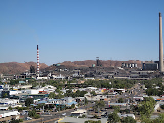
Mount Isa is dominated by the mine - a huge, ugly thing - with the town sprawling below.


I remember hearing a year or so ago about the number of Mount Isa children being affected by lead poisoning, but haven't heard anything recently.

Across the road from us is a group of dongas where 195 fly-in fly-out miners are housed.  We're going over to their 'restaurant' for dinner tonight, even though alcohol is not allowed.  (Don't know how Eric will manage, but there's a first time for everything.)  We're told that the miners are breath-tested before they get on the bus to work each morning.

The weather's warming up - 28 today and 30 forecast for tomorrow, so it's into shorts (well, three-quarter trousers) and t-shirts.  Next step will be the thongs.  Sorry to mention this to all the shivering Melburnians.

Tomorrow will be a relatively short hop to Camooweal on the Queensland side of the border with the Northern Territory.  Then there'll be three fairly solid days of travel to get to Katherine on Monday, 18th.

Monday, 11 June 2012

RICHMOND

Where Hughenden was on the edge of the ancient inland Eromangan Sea and has many dinosaur fossils, Richmond was under water, so the exhibition centre, Kronosaurus Korner, contains mostly fossils of gigantic marine creatures, as well as ammonites, belamnites, etc., etc.


There's a real sense of fossil fever around these parts.  Most finds have been discovered by farmers going about their everyday business out in the station paddocks when they turn over a rock and see a fossil, or notice a fossilized nose sticking out of the side of a creek bed.  It must be exciting to make such a find.  With such heightened awareness, fossils are coming in thick and fast and the palaeontologists just can't keep up.  There's an area outside Richmond where the public can search, but I'm afraid I'm fossiled out for the time being at least.

At the risk of repeating myself, we're impressed by the amount of effort these towns put into providing exhibitions, information centres, recreational facilities and general beautification of streets, parks, etc. Richmond has a Bush Tucker Garden, set out beside the lake, where trees and plants are labelled and their traditional uses by aboriginal people are explained.

We're driving to Mt Isa tomorrow where we'll prop for a few days.

Sunday, 10 June 2012

WINTON AND HUGHENDEN

Still heading north, the next stop was Winton and the start of the 'Dinosaur Trail'.  Just out of Winton on the top of a mesa (known locally as a jump up) is the newly established Australian Dinosaur Centre.  Set up as a non profit organisation by the station owners who discovered significant dinosaur fossils on their property, it currently employs 10 people full time. Members of the public can volunteer to work in the laboratory after undertaking some training.  Currently they've got heaps more fossil-bearing rocks than they know what to do with - about 35 years' work, they estimate - so if anyone has three months to spare...


From the top of the mesa, you look over what was the ancient Eromangan Sea.  Somewhere under the plain are the fossils of ancient marine creatures and dinosaurs, as well as the Great Artesian Basin.
View from the top of the mesa

About 110 kms south west of Winton is Lark Quarry, the only known fossilized footprints of a dinosaur stampede (shown in the TV series Australia: the time traveller's guide).


The makers of the film Jurassic Park hired a palaeontologist who visited Lark Quarry and, by studying the footprints, figured out how dinosaurs walked, that is like emus - one foot directly in front of the other.  I think I should now have a look at, at least parts of, the movie as I haven't seen it.

I expected to have to go down into a quarry to see the footprints, but they've built an ecologically self-sufficient shed, that maintains a constant temperature, over the fossils to preserve them as they're so very precious.


From Winton to Hughenden, the terrain was a vast plain of golden Mitchell grass with only the occasional tree to be seen.  Hughenden sits on the Flinders River, Queensland's longest river, which flows into the Gulf of Carpentaria.

For small, outback towns, both Winton and Hughenden have done a terrific job with their interpretive centres.  Winton has the very extensive Waltzing Matilda Centre, so called because Banjo Paterson wrote the lyrics to the song while visiting a station near Winton in 1895.  It took us a good two hours to go through the exhibits, and we hadn't finished by chuck out time.

Hughenden has the Flinders Discovery Centre and an incredible collection of fossils, as well as Hughie the Muttaburrasaurus.


About 75 kms north of Hughenden is the spectacular Porcupine Gorge:


It was steep enough going down, but seemed even steeper coming back up. Hot too, especially with the sun radiating off the rock.


Tomorrow we turn west for Richmond, the third and last town in the Dinosaur Trail triangle, then continue west towards the Northern Territory.

Saturday, 9 June 2012

LONGREACH

The main attractions in Longreach are the Stockman's Hall of Fame and the Qantas Museum. 


The Stockman's Hall of Fame was much better than expected with extensive and detailed displays covering Australia's prehistory onwards, all beautifully presented.


The 'show' was more stand up comedy (if you can apply that term to a bloke on a horse) than rodeo style and highly entertaining.


Eric was keen to see the Qantas exhibits.  It was very strange driving into Longreach through open plains of grass to suddenly see the tail fin of a Boeing 747 stuck out in a paddock.


Viewing of the 747 was closed as the nose is sinking into the ground.  Instead, we got to see over a  Boeing 707 short, the first of only 13 ever produced. It had been given a luxurious fit out in the hope of selling it to a rich Arab.  Unfortunately, they covered the armchairs with pig leather, so the Arabs wouldn't touch it. The 13th plane, we were told, is owned by John Travolta.


A slippery drive along some muddy tracks took us to the pretty Lilly [sic] Lagoon on the Thomson River.


Saturday, 2 June 2012

THARGOMINDAH – CHARLEVILLE via Eromanga and Quilpie

Next morning (Monday 28th May) we hit the road again and did the loop around to Eromanga where significant dinosaur fossils have been found recently.  Eromanga claims to be the Australian town which is furthest from the sea. As we couldn’t find any reference to the fossils in their Historical Museum – just pioneer history – plus the camp grounds were not appealing, we continued on to Quilpie for a dinner of spit-roasted pork and johnny cakes, followed by a live performance of country music.  Fabulous! – even with the earplugs in.
Eric was in luck again the next night as the Charleville camp put on a roast lamb and apple pud dinner. We should have gone to the Cosmos Centre that night, but we booked for the following night when, you guessed it, cloud covered the sky and not one star was to be seen, so the event was cancelled.  By this time I’d jacked up about eating any more camp-provided dinners, and even the exciting prospect of yabby races couldn’t entice me along.
During a prolonged drought in the early 20th century, a local meteorologist had the idea of using these vortex guns to fire at clouds in an effort to produce rain.  No successes are recorded.

CHARLEVILLE – BARCALDINE
Pointing the rig north again, we made it to Blackall on the Barcoo River in time for lunch, on the way passing through pine plantations which eventually gave way to fine looking country with beautiful old trees lining the road.   There was quite a bit of wildlife around – not all of it road kill - ‘roos, emus, dingoes, as well as the ferals.
Originally colonised by sheep and squatters following exploration by Major Mitchell, Blackall has a monument to the gun shearer Jack Howe whose world record of shearing (with blade shears) 321 sheep in under 8 hours still stands today.  It also boasts the Australian Labor Federation Memorial which commemorates the formation of the first Shearers’ Union in December 1886, though we didn’t have time to visit this.
Pressing on to Barcaldine on the Alice River, we made camp just before a torrential downpour hit, which continued all night.  It’s at times like this that we’re thankful that we have a hard top caravan, with heating and cooling, though recent nights have been a bit too humid for the electric blanket.
Next morning was grey and drizzly with a cool wind when we set out to view the sculptured memorial to the Tree of Knowledge.  The main drag of Barcaldine is about a kilometre long, lined on the south side, opposite the railway line, with old pubs, about six all told.  The town was full of caravans - caravans parked each side of the road and in all the camping spots, but then Barcaldine sits at the crossroads of north-south and east-west highways.
According to legend it was under the Tree of Knowledge that the shearers met during the Great Strike of 1891, which led to the formation of the ALP (and the Pastoralists Union).  Someone poisoned the actual tree which has been preserved as the centrepiece of the monument, with recycled timber, representing the blades of shears, recreating the size of the tree canopy.

Next stop was the extensive (spread out over about an acre) Australian Workers Heritage Centre that commemorates the history of various types of workers.

BARCALDINE - LONGREACH
This morning we drove about 100k west of Barcaldine to Longreach on the Thomson River.  We may have just got out in time as we’ve been told that Barcaldine copped another downpour.  Drizzle accompanied us and the road had plenty of water over it and in the numerous potholes, as well as what seemed like corrugations.  Corrugations on bitumen?  Road trains, sometimes four trailers long barrelled past, while up ahead some caravans pottered along at about 75-80 kph.  A challenging, though fortunately short, drive.  Eric has got into the groove of towing and is now feeling very comfortable behind the wheel.
The dirt roads in the park are muddy, but probably won’t take long to dry out if the sun can make it through.  I think more rain is predicted.  It seems that sunny Queensland has turned into a permanently drenched state.
Tomorrow we’ll see what Longreach has to offer.


Friday, 1 June 2012

INNAMINCKA AND THE DIG TREE

What a wonderful thing a bitumen road is!  After the bone jarring road between Innamincka and just past the Queensland border, not to mention the roads around Innamincka, it was a relief to hit the bitumen again. 

Queensland Roads is to be congratulated for providing a sealed road almost all the way to the border.  Towards the SA border wooded areas give way to open plains, dotted with oil and gas fields. 
The Dig Tree is on the Queensland side of the border on Nappa Merrie station (owned by Santos and leased back by S. Kidman Ltd).  Nothing like the creek that Sturt saw when he named it in 1845 , the Cooper is presently a swiftly flowing river. 

The road out to the Coongie Lakes was cut:

but a tour up and down the river took us to the sites where Wills died, where Burke died, and where King was finally found by the rescue party.
We spent two nights at the Innamincka Hotel:


in relative luxury, so we didn’t have to use the Public Amenities Block:
though the camp sites by the river looked very appealing.  If the weather had been warmer we'd have been happy to camp there.
Innamincka is a dry and dusty place:

but then you come to the Cooper lined with grasses, bushes, splendid trees - many of them very old - and teeming with birdlife.

On the way to the site of Burke’s death, we visited the picturesque Cullyamara waterhole:

It was great to see all these places associated with the Burke & Wills expedition which we'd read about in Sarah Murgatroyd's excellent book The Dig Tree.  We looked for, but didn't find, the nardoo plant that aborigines washed and ground and fed to the explorers.  In their efforts to survive, Burke & Wills ate this plant, but as they didn't prepare it properly, they slowly poisoned themselves.  Evidently King's relationship with the locals was better, so they looked after him and he survived.
Returning to Thargomindah we took a 20k detour to have a look at the old Noccundra pub and waterhole.  There’s nothing else left at Noccundra, but some campers had set up in a pretty nice spot by the waterhole.