Wednesday, 5 June 2013

CARNARVON GORGE, QUEENSLAND

What a lovely spot Carnarvon Gorge is.  Though it's somewhat off the beaten track, it's well worth the effort of getting there. You also need to be quite fit to manage the full thirty kilometres length of the gorge, plus numerous side trips to view various formations, each one of which adds at least two to three kilometres to the trek.  To see the gorge properly, the best thing would be to do as we saw one young couple doing and carry a pack and camping gear. They were planning to camp at Big Bend, 9.2 km from the Visitor Centre.  It's also possible to get helicopter flights over the gorge for $99 per person, which would give an idea of the extent of the place but not the finer detail.

We only managed to get to the first scenic highlight inside the National Park, the Moss Garden, and that was seven kilometres in total, some of it quite steep.


A further 1.8 kms along the main track, then 600 metres in and finally up a ladder is the Ampitheatre, which we would have liked to get to, but Eric's legs just couldn't manage quite that much. Still further along is an aboriginal art gallery. Nevertheless, just walking along the track, seeing the stately white-trunked trees outlined againt the escarpment and listening to the birds was very enjoyable.


The start of the main track:

Large stepping stones make crossing Carnarvon Creek easy

From the middle of the creek

And looking the other way

Along the main track:


At the start of the main track is a short two kilometre 'nature trail' walk:


We camped at Takarakka Bush Resort which is about four kilometres from the National Park Visitor Centre.  It's a pleasant spot and we picked a good time to visit.  The weather was warm but mostly overcast, so good for walking, though we did have one day when it poured rain.  The resort manager dismissed the downpour as "just a shower to settle the dust". A bit further down the road towards the park is another accommodation place and restaurant for non-campers (Carnarvon Gorge Wilderness Lodge).


Between the camp and the Visitor Centre, but still technically part of the Gorge (I think) are a number of places to visit which involve shorter walking distances.

Rock Pool
Warrumbah Creek Gorge:


Mickeys Creek Gorge track:


So even though we didn't get very far along Carnarvon Gorge proper, we still managed to do quite a bit and thoroughly enjoyed the whole experience.

Friday, 26 October 2012

MARGARET RIVER to ESPERANCE via WALPOLE and ALBANY

From Margaret River we were able to visit areas south of Cape Leeuwin, down to Port Augusta and Cape Naturaliste.  The two capes are at either end of the bit of land that juts out in WA's south-west corner.  The coastal strip remains in a fairly natural state and, while hardy souls can do the seven day walk from one Cape to the other, we contented ourselves with walking bits of the track from various locations.


Margaret River alongside our picnic lunch spot

At the southern end is Cape Naturaliste:

Cape Naturaliste with Indian Ocean on the right (west) and Southern Ocean on the left (east)
On the drive between Margaret River and Walpole, we took a detour to check out one of the last remaining remnants of Tuart Forest  - very little left in this area.

WALPOLE

The main attraction of the small town of Walpole was its proximity to the Giant Tingle Forest and, a little further down the road, the 'Valley of the Giants' and the tree top walk amongst the giants.  Our camp ground turned out to be in a delightful bush setting with kangaroos wandering about and a view of the ocean.


Karri tree
Base of giant Tingle tree
And, as always, the flowers:


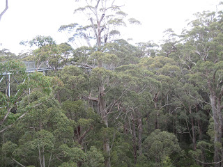
One day we did the  tree top walk which allows you to get nearer the canopy.


At Circular Pool:


Coastal flowers:


ALBANY

Albany was lovely, placed at a site of natural beauty.  Hills run straight down to the harbour with its many bays, coves and small islands.  It was the first European settlement in WA in 1829, three years before the Swan River Colony was established.


There is a military museum at the old fort, dating back to the 1890s, on top of a hill overlooking the bay.  It was in Albany Harbour - King George Sound to be precise - that the Anzac fleet was assembled before sailing off to the Middle East and World War 1.  We didn't realise that so many ships were involved - I counted more than 30 on one diagram.  On the hill, in various sections, are items of equipment from the various wars and branches of the defence force.


A tour of the old whaling station about 20 kms west of Albany was surprisingly interesting, though also horrifying.  It only closed down in 1978.  According to our guide, after years of protests, Green Peace came in and shut it down and that was that.  I recollect that a novel of Tim Winton's (was it Shallows?) re-created the goriness of the operations at this station.

Whaling ship

Further west along the coast, the wind farm supplies 80% of Albany's electricity requirements.


ESPERANCE

In contrst to Albany, the next largest town on the south coast, Esperance, is fairly flat, though there are fine views to had from a hill top lookout just west of the town.


Looking out over the Bay of Islands:


In December, 1792 two French ships, Recherche and Esperence took shelter in the lee of Observatory Island:


Observatory Island


East of Esperance, Cape le Grand National Park consists of low hills, granite outcrops and coastal heathland.  The coastline here is just gorgeous - white sand, torquoise water and the ever present flowering shrubbery.